IBEX - ISRAEL’S BEST EXPERIENCE
Since 2015, I am a licensed Israeli tour guide in Dutch, English, German and Hebrew. My expertise is in planning and guiding (innovation) tours for people who would like to get to know Israel.
A taste of my planned tours are available here:
Israel: North
+ Oranit Cave, Carmel Mountain
+ Montfort Crusader Fortress and Nahal Kziv
+ Givat Hamore, Yizrael Valley, Yizrael Valley
+ Osafiya Region, Carmel Mountain
+ Meron Mountain
Israel: Center
+ Bnei Barak – history, culture, religion & innovation
+ Jaffa’s churches
+ Ha’Nadiv Gardens and Nature Reserve, Alexander Stream and Agamon Hefer
+ Rosh HaAyin Izbet Zarta (Eben-Ezer)
+ Kedoshim Forest, Martyrs’ Forest, Jerusalem Mountains
+ Sidni Ali Beach and Mosque
+ Ben Shemen Forest (Modi’in) Area
Modal title
IBEX - ISRAEL’S BEST EXPERIENCE


IBEX - ISRAEL’S BEST EXPERIENCE

Israel
+ Tour guide course 2013-2015
VIEW IN PDFPreparations in advance: אני משתפת את חוברת תכני ההדרכה (טבלאות) שהכנתי במהלך לימודיי בקורס מורה דרך ארז בשלוחת תל אביב של ביה"ס לתיירות של אוניברסיטת חיפה החוברת נגישה באתר האינטרנט הפרטי שלי לסטודנטים ולבוגרי קורס מורי דרך בנימה אישית, הכנת הטבלאות סייעה לי להתכונן למבחן הסיום בכתב במשרד התיירות אני ממליצה בחום להכין לבד תכני ההדרכה ולהעזר בחוברת זו רק כדוגמא הלימוד הטוב ביותר הוא בהתנסות אישית של כתיבת תכני הדרכה, הצגתם בפני עמיתים ושיפורם עד לרמה הנדרשת מאחלת הצלחה לכל הנבחנים העתידים
IBEX - ISRAEL’S BEST EXPERIENCE

IBEX - ISRAEL’S BEST EXPERIENCE


Israel: North
+ Oranit Cave, Carmel Mountain
VIEW IN PDF5-hour circular hike from Tirat Ha’Carmel to the Oranit Cave, and back. Dine in Fureidis.
By Racheli Kreisberg 26 December, 2020
Preparations in advance: Good hiking shoes, water, hat, sun lotion, map of the Carmel
Drive from the Center to the Kedem Hotel, Tirat Hacarmel near the Monheim Park
Park the car at the entrance of the Monheim Park, Tirat Hacarmel Tirat Carmel was built on the ruins of the Arab town of al-Tira. The Crusaders named it “St. Yohan de Tire”. It was an agricultural area with wheat fields, goats rearing and other farms and ruled by the Ottomans in late medieval and renaissance times. The town was known for its production of olives and almonds. By 1945 it had an agricultural Muslim community with a Christian minority. During the War of Independence, a-Tira was attacked three times. The first time on December 12, 1947, the Etzel movement attacked the village, killing 13 people. The second time was between 22-25, 1948, during which the Hagana attacked Haifaas well as al-Tira. The village was finally occupied by the IDF on July 16, 1948 and its citizens were deported to Jenin, Nablus and Tulkarem.
Tirat Hacarmel is a twin town of Maurepas, France, Germany Monheim am Rhein, Germany, Hungary Veszprém, Hungary and Azerbaijan Shamakhi, Azerbaijan.
Brunch at picnic area near the beginning of the red marked trail.
Circular hike
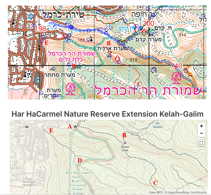
Start at point A and Ascend the red marked trail towards Oranit Cave (point B).
Facing the Oranit cave, there are two main entrances. Explore the left cave and return to the entrance of both caves.
Continue walking on the red trail that takes you into the right cave. It requires a bit of crawling at one place, but this is not difficult. Climb down on the rock towards the path. Careful.
Continue walking on the red trail until you get to a wide path (marked on the map in black, point C); walk North West until you reach a spectacular look-out of the Mediterranean Sea (point D).
Along the route you will see beautiful flowers.
Walk down towards Tirat Hacarmel. There is no marked path. Use “Amud Anan” to walk on the “path”.
Once you reach the bottom of the mountain, be very careful where you descend onto the street. Best to walk towards the junction of Alon and Rimon street (point E).
Drive from Tirat Hacarmel to the center of Fureidis. You can park near the King store Almash ‘hadawi.
Dine at El-Asmar Brothers
IBEX - ISRAEL’S BEST EXPERIENCE


Israel: North
+ Montfort Crusader Fortress and Nahal Kziv
VIEW IN PDFBy Racheli Kreisberg 20 March, 2021
Preparations in advance: Good hiking shoes, sandals or slippers to walk in water, hat, sun lotion, water, map of Western Galilee (Upper Galilee Trail Map)
Drive from Center to Mitzpe Hila
Mitzpe Hila was established in 1980 in the Western Galilee, as part of the “Lookouts in the Galilee” plan, with residents initially living in prefabricated homes imported from South Africa.
The “Lookouts in the Galilee” plan was aimedat establishing Jewish settlements in the Galilee in the years 1979-1980 during the Menachem Begin Government. The decision to implement the hill top villages was made in April 1979, at a meeting of the Joint Settlement Committee of the Government of Israel and the World Zionist Organization. The establishment of 30 “lookouts” over a period of 6-8 months was approved and the program was publicly called “Judaization of the Galilee.” According to its initiators, the aim was to increase the percentage of Jews in the mountainous Galilee region. Within the framework t of the plan, many small Jewish settlements were set up during a short period of time and were called Mitzpim (singular Mitzpe).
Mitzpeh Hila was originally named Mitzpe Ziv after Har Ziv, the mountain on which it was built. It was later renamed Mitzpe Hila. Katyusha and Grad rockets fired by Hezbollah in the 1990s landed in the village, as did more rockets during the 2006 Lebanon War against Hezbollah.
Leave your car at the Nahal Kziv Nature Reserve Parking Area (חניון רכב שמורת נחל כזיב). The parking lot is at the inter-section of the red and black trails.
Circular hike with multiple stops
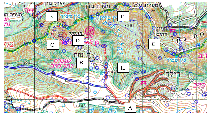
Walk from the parking area (A) towards HirbetNahaton a wide, unmarked path (use Amud Anan to navigate).
Visit HirbetNahat (B)
Hirbet Nahat was a Byzantine settlement (4th-6th centuries CE) which was abandoned at some stage. In the early 13th century, the land was bought by the Crusaders who setup an impressive large quarry for building stones. It is believed that this quarry supplied the stones used to construct the Montfort Fortress. At the center of the quarry, there is a square rock stage about 6 meters high with a bell-shaped cistern used during the Byzantine period. A stair case carved into one of its walls leads to the top. The Crusaders built a turis (guard tower), a two-story stone structure used for protection. Based on the architecture of other Crusader guard towers, it had on all four sides firing slits; above the entrance opening a cornice was erected on which a wooden platform stood from which boiling oil could be poured or stones could be rolled on anyone trying to enter the tower (see picture of the Kolossi Castle – a former Crusader stronghold on the south-west edge of the Kolossi village, 14 km west of Limassol, Cyprus).
Walk eastward until you arrive at a wide path; continue walking northwest towards the Montfort Castle (C).
At the “bridge” take the righthand red path and climb towards the Montfort Castle (D)
The Montfort Castle: In the twelfth century, there was a much smaller castle in this area, meant to defend the estates of the local feudal lords; its remains lie in what is today Mi’ilya. In 1220, Hermann von Salza, head of the Teutonic knights, purchased a large tract of land in the Western Galilee, encompassing Montfort. The knights called the place Starkenburg (Strong Fort, a German translation of the French Crusader name Montfort. In 1226, the knights began building one of the most beautiful Crusader castles in the Land of Israel. It is not clear why they built it in this location, which lacked any special strategic value. It may have been aimed as a defense against local residents, who were not particularly fond of the Teutonic knights. In 1266, at the beginning of Mameluke sultan Baybars’ attempts to conquer the Galilee, one of his commanders tried to take Montfort and failed. Five years later, the sultan himself stood opposite the castle walls. The siege began on June 8, 1271, and the outer fortifications were conquered three days later. The sultan promised a large sum for each stone plucked out of the wall. The fighting was fierce. Eventually, after it was agreed that they would leave as free men but without their possessions and weapons, the castle’s defenders laid down their arms. They moved to Acre, managing to take with them the castle’s archive and its treasures, which were subsequently transferred to Venice and from there to the Teutonic Malbork fortress in Marienburg, Poland where they remain to this day. Montfort Castle was never inhabited again .
The end of the shaft that emptied the fort’s sewage can be seen at the bottom of the south side of the western hall where probably the castle’s toilets were located.
Descend on the same path and return to the “bridge” (C).
Take a right on the red path and walk towards the Ein Matzor spring, Nahal Kziv (E). Ein Matzor is a spring whose waters emerge below the ruins of a two-storey stone building and a dam on the southern bank of Nahal Kziv, at the foot of Montfort Castle. The building and the dam date back to the Crusader period. Archaeologists who explored the site determined that the dam created a lake whose water was used for irrigation. The building initially served as a flour mill, but a more elegant upper floor was later added, and apparently the building was then used to house pilgrims and guests.
Walk east on green trail, enjoy the streaming water and make frequent stops. (F)
View the blooming laurel trees (ער אציל). Laurus nobilis is an aromatic evergreen tree or large shrub with green, smooth leaves. It is variable in size and can reach between 7-18 meter. It is native to the Mediterranean region and is used as bay leaf for seasoning in cooking. Most commonly, the aromatic leaves are added whole to Italian pasta sauces.
Visit the Um El Furan flour mill (טחנת אום אל פורן), one of 12 mills that operated in Nahal Kziv .
This is one of the many flour mills built on the Nahal Kziv stream. The aqueduct that carried water to the mill chimney is visible on the roof of the building, perpendicular to the dirt road. Go down the right path that starts near the tree next to the western wall. At the end of the path, we will enter the opening of the mill, which is on its southern and lower side. The temperature there is noticeably cooler. It is evident that the room to our left was used for grinding because of the square opening through which the rod which rotated the mill wheel rose. From the outside we can see that the lower part of the mill house is built of extra-large stones, and some believe that they were taken from Montfort Fortress. With the construction of engine-operated flour mills in Tarshihain 1932, the water-operated flour mills ceased to operate. In this section of the Kziv stream, the mills stopped operating before the establishment of the State of Israel.
Walk towards Ein Tamir on the green trail. (F)
Prior to reaching Ein Tamir take the steep black path (G) and climb up hill (catch your breath from time to time !). (H)
Return to parking area (A)
IBEX - ISRAEL’S BEST EXPERIENCE




Israel: North
+ Givat Hamore, Yizrael Valley
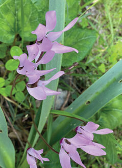
VIEW IN PDFEmek Yizrael Valley, Iris Nazareth wild flower.
By Racheli Kreisberg 7 March, 2021
Preparations in advance: Good hiking shoes, water, hat, sun lotion, bible (book of Judges), map of Tabor and Gilboa region The tour includes two stops: the first at Megiddo Airfield and the second at Hamoreh Hill (Givat Hamoreh).
Drive from the Center to the Megiddo Airfield 200 meters south west of the Sargel junction
Park at the Megiddo Airfield parking
Megiddo Airfield, known as Shachar 7 by the Israel Defense Forces, is an Israeli airfield located in the Jezreel Valley near Tel Megiddo and 3 km southwest of Afula. Opened in 1942 as RAF Station Megiddo it was used as an auxiliary field to RAF Station Ramat David. It currently handles private and agricultural flights. It formerly served as an Israeli Air Force base and was decommissioned in the mid-1980s.
Walk along the marked path to enjoy colorful anemones
What colors are the anemones?
Anemone coronaria is an east Mediterranean species which grows in diverse habitats around the Mediterranean Sea. It exhibits an extreme case of Flower Color Polymorphism (FCP) with red, white and purple-blue discrete colors, and with at least 30 gradual color variants. Anemones grow in semi-arid areas in southern Israel. Many other sorts have various mixed colors, while a few northern ones are purely white. Consequently, it has been hypothesized that the color red is connected to aridity, while the white and purple-blue flowers are connected to rock and soil properties . The red flowering anemones in the arid south have narrower leaves in comparison to the same sort in the north; it is logical to assume that the smaller leaves are more resistant to aridity. The distribution of the color of the anemone in Israel may also be related to soil type. Pure white and purple-blue flowers grow mainly on chalk-free soils on limestone or basalt rocks, respectively, and the red variety is dominant on relatively dry and calcareous soils. However, this explanation does not seem satisfactory, since the red sort is also found growing close to other color groups in similar habitats, and more detailed research is needed to clarify this aspect.To conclude, so far there are no explanations why the various flowers are almost exclusively red and why other kinds are of varied colors.
Drive from Megiddo Airfield to Kfar Dahi Park in the vicinity of the Mosque in Dahi.
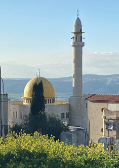
The Dahi village is an Arab village in northeastern Israel. Located on Givat HaMoreh (Jebel Dahi in Arabic) overlooking Afula, it falls under the jurisdiction of the Bustan al-Marj Regional Council . The village is situated at an altitude of 550 meters above sea level. As of 2019 it had a population of 703. Dahi was named after Dahia Bin Khalifa al-Kalbei.
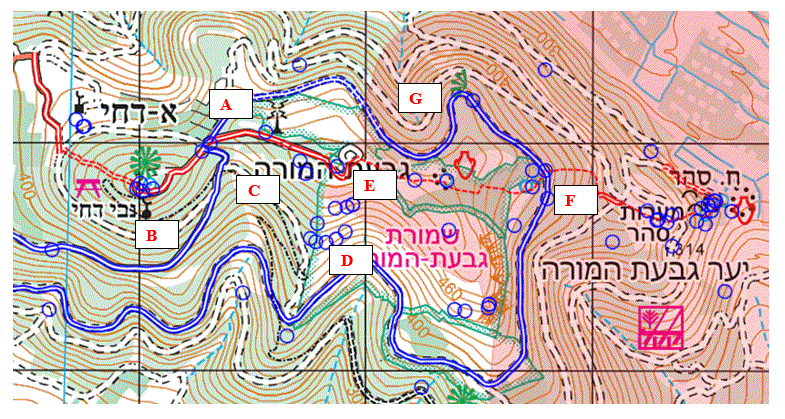
Circular walk in Givat Hamore region (from A to G).
Walk from the outskirts of the Dahi village (A) towards the tomb of Nebi Dahi (prophet Dahi) and the watch tower (B).
Visit the tomb and the watch tower (מגדל התצפית) B.
The blue-domed shrine that, according to Muslim tradition, is the burial place of Dahia Bin Khalifa, also known as Al-Kalbi. Tradition relates that he was a follower of the Prophet Muhammad who was killed near the Harod spring while commanding his army in battle against the Byzantines. His faithful dog is said to have dragged his lifeless body to the top of the hill, before breathing his last and being buried alongside his master.
The residents of the nearby village of Al-Dahi, like the inhabitants of the other Arab villages in the Givat HaMoreh region, belong to the well-connected Zuabi family, who claim descent from the Prophet Muhammad. They settled on the fringes of the Yizrael Valley after making their way to the Land of Israel in the middle of the 18th century. Nabi Dahi became renowned as a healer of the sick, and residents of the Arab villages in the region would bring their ailing children to sit “beside the prophet” until they recovered. People from the village of Al-Dahi still come to pray beside this ancient tomb and they bury their dead near it. The fence that surrounds the cemetery blocks all access to the tomb .
Picnic near Nabi Dahi
Walk north east on the blue marked path reaching Givat Hamore (C) and make a right (south east) on a dirt path.
Givat HaMoreh is 517 meters above sea level – higher than Mount Gilboa and only slightly lower than Mount Tabor but is not termed “Mount Hamoreh”. The reason is that its name as a “hill” (גבעה) is identified as the place where the Midianites camped prior to their battle with Gideon: ry “Then Jerubbaal, who is Gideon, and all the people that were with him, rose up early, and pitched beside the well of Harod: so that the host of Midianites were on the north side of them, by the hill of Moreh, in the valley,” (Judges 7:1).
Although there is almost no doubt about the identification of the site, the origin of the name Moreh is unclear. Some believe it means “high place,” and Givat HaMoreh does indeed tower conspicuously above its surroundings, while others are of the opinion that the name comes from that of a local holy man or seer who could “indicate” (moreh in Hebrew) future events. Another interpretation of the name links it to the yoreh, the first rain of autumn, in accordance with Joel 2:23: “[…] the former rain (Hebrew moreh) and the latter rain in the first month.” Perhaps the holy man who dwelt on the hill of Givat HaMoreh was endowed with rainmaking abilities, or perhaps the name derives from a rainmaking cult that once thrived at the site.
Continue towards the Givat Hamoreh Nature Reserve with the Iris Nazareth wildflower (D). On the Amud Anan map you can see a few blue circles marking the location of Iris Nazareth (Iris bismarckiana) wildflowers. Iris Nazareth is colored white-light blue with black-purple dots. It was named after the goddess “Iris” – the Greek goddess of the rainbow. Its beauty also served as a source of inspiration for a variety of decorative models and today it appears in the symbols of the Society for the Protection of Nature in Israel (SPNI).
Ascend to the right of the aerial masts till you reach a plateau and a “car parking” area (E). The aerial masts can be reached via a vehicle track that ascends from the junction of the blue- and red-marked roads.
A two-hour easy circular hike starts on the red marked path, walking east until you reach the blue marked path (F).
The Byzantine wine press – a large fine wine press hewn into the rock which can be seen at the side of the red-marked footpath some 300 meters to the east of the eastern aerial masts, just before the olive grove. Still visible at the site is the large treading floor from which the freshly pressed grape juice (must) was channeled into a large pit before being collected for fermentation.
Continue on the blue path till you reach the car (G).
IBEX - ISRAEL’S BEST EXPERIENCE




Israel: North
+ Osafiya Region, Carmel Mountain
VIEW IN PDFKhirbet Alaa A’Din, Bayonet Castle, Vineyard Farm in Osafiya.
By Racheli Kreisberg 26 December, 2020
Preparations in advance: Good hiking shoes, water, trekking poles during winter to avoid slipping on wet rocks
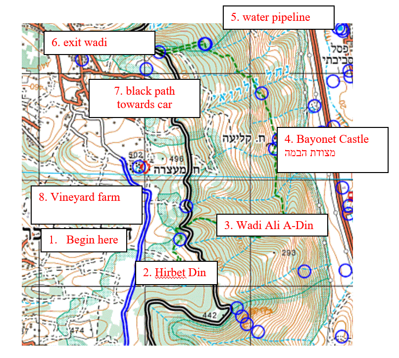
Drive from the Center (Tel Aviv, Sharon Area) to Mount Carmel
Mount Carmel, Hebrew Har Ha-Karmel, divides the Plain of Esdraelon (ʿEmeq Yizreʿel) and the Galilee (east and north) from the coastal Plain of Sharon (south). A northwest–southeast-trending limestone ridge, about 26 km long. Its seaward point, Rosh ha-Karmel (Cape Carmel), almost reaches the Mediterranean.
The Carmel mountain’s highest point, 546 meters above sea level, is northwest of the village of ʿIsfiyā. The name Carmel dates to biblical times and is derived from the Hebrew kerem (“vineyard” or “orchard”) and attests to the mountain’s fertility even in ancient times.
Circular Hike
The route begins at dirt road marked blue where you can park your car (1) at the cross section with the green sign of a walking path.
Walk on the green marked path eastwards towards Khirbet Din ruins (2). Note that the path is hindered by barbered wire (careful) and passes through agricultural land.
Khirbet Alaa ‘Adin was inhabited by Druze residents of the Carmel. The village was built on a Byzantine ruin during the rule of the Ma’n(Fakhr al-Din II) and the Druze settled there for a period of 200 to 250 years. The Ma’n family, to which Fakhr al-Din belonged, established itself in the Chouf (Shuf) area of the southern part of Mount Lebanon.
After Ibrahim Pasha’s army was defeated in Syria he –as revenge- started destroying Druse villages in the Carmel area, among them Khirbet Alaa ‘Adin. This took place in the years between 1831-1840. Only two Druze villages remained: Osafiya and Daliat El-Karmel.
The green marked path descends steeply in a natural forest till you reach the black signed dirt road. Walk North on the Nof HaCarmel road (דרך חוף כרמל) until you can turn east (right) into Wadi Ali A Din which will take you steeply down for about 300 meters (3).
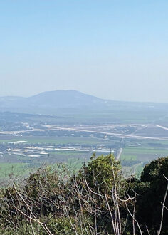
The path turns north towards Bayonet Castle (מצודת הבמה) (4) with a beautiful view of the Yizrael Valley.
From the bayonet Castle, the route steeply ascends in a northwest direction within the thick Mediterranean forest of the Carmel, crossing the Al-Royi Wadi and reconnecting to the Nof HaCarmel road south of Nahal Hosifa, where the green marked path ends (5,6).
Continue on the black marked path, east of the Nof HaCarmel road. Turn right onto the Nof HaCarmel road and continue till the vineyard farm of Osfiya (חוות הכרמים) (8). Continue west till you reach the blue marked road and walk south towards the car.
Drive to restaurant Amasha
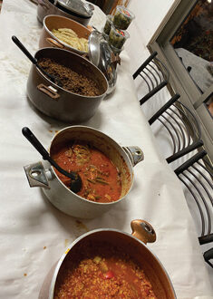
Lunch at Amasha Restaurant
Drive back to the Center
IBEX - ISRAEL’S BEST EXPERIENCE


Israel: North
+ Meron Mountain
VIEW IN PDFMeron Mountain tour
Khirbet Shema (Galilean Te’ko’a), Ein Zeved, Nahal Meron, Talmudic ancient synagogue in Meron.
By Racheli Kreisberg 20 August, 2021
Preparations in advance: Good hiking shoes, water, trekking poles during winter to avoid slipping on wet rocks
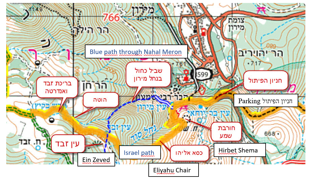
Drive from the Center (Tel Aviv, Sharon Area) to Haredi bakery at the entrance of Meron villageמאפיה קונדיטוריה חלב חיטים בהשגחת הבד”ץ עדה החרדית
Drive South on road 886 towards Kfar Shamai to 32.979464, 35.443275. Turn right at the sharp hairpin and park the car. The parking is also called “Hen’yon Ha’ Pi’tul” חניון הפיתול
Circular hike from parking area to
- Khirbet Shema (through Israel National Trail), Ein Zeved, Nahal Meron (through Blue trail)
or the other way around:
- Nahal Meron (through Blue trail), Ein Zeved, Khirbet Shema (through Israel National Trail)Highlights along the route:
- Khirbet Shema – an archaeological site from the late Roman and/or Byzantine period which was excavated by Duke University archeologists Eric Meyers, Thomas Kraabel and James Strange between 1970-1972. There are ruins of a Second Temple synagogue, which was damaged by an earthquake in 306 CE, after which the synagogue was rebuilt, only to be destroyed by another earthquake.
Khirbet Shema is identified as “Tekoa of the Galilee” and it was a kind of suburb of the city of Meron (situated about 600 meters southeast of Meron). Therefore, it is written in the Jerusalem Talmud (7th, 9, 3): “I will eat on the olives until they can from Meron and Gush Halav” (אוכלין על הזיתים עד שיכלו ממירון ומגוש חלב). Rabbi Shimon Ben Yochai had a yeshiva in Tekoa, of which Rabbi Yehuda HaNasih was part in his youth. - At the middle of the ancient cemetery of Khirbet Shema, there is a clearing with a large, monumental tomb in its center.
- A solitary, large natural stone known as Elijah’s chair. This stone is mentioned frequently in the tales of the kabba lists. The students of rabbi Isaac Luria Ashkenazi (the Ari), for example, said that after the Messiah arrives, he will take a seat here.
- Ein Zeved is a seasonal spring that flows into a small pool at the foot of an ancient tree. The pool is home to a few salamanders (rare and in danger of extinction). This is a nice place to take a break and enjoy the stunning view. On clear days, snowcapped Mount Hermon can be seen in the distance.
- Meron River – from Ein Zeved follow the blue trail and descend to the parking area through the Meron river. Caution in the winter due to slippery path.
Drive from parking to Meron Old Synagogue (parking is at the bottom of the hill, in a large parking lot)
Climb up to Old synagogue
Meron Old Synagogue – connection to the Messiah
The synagogue in Meron is one of the largest ancient synagogues in the Upper Galilee. It is about 2,000 years old and has been a focal point for pilgrimage for hundreds of years. In Galilean Jewish traditions the synagogue is associated with the coming of the Messiah.
The Kabbalistic Book of Zohar teaches that the Messiah will come from the tomb of Rabbi Shimon Bar Yochi, the 1st century A.D. Kabbalistic teacher, at Mt. Meron. According to the Zohar, the Messiah will travel from Mt. Meron through Tzfat on his way to Jerusalem, where he will inaugurate the Messianic Era.
Drive back home
IBEX - ISRAEL’S BEST EXPERIENCE

IBEX - ISRAEL’S BEST EXPERIENCE


Israel: Center
+ Jaffa’s churches
VIEW IN PDFBy Racheli Kreisberg10 June, 2017
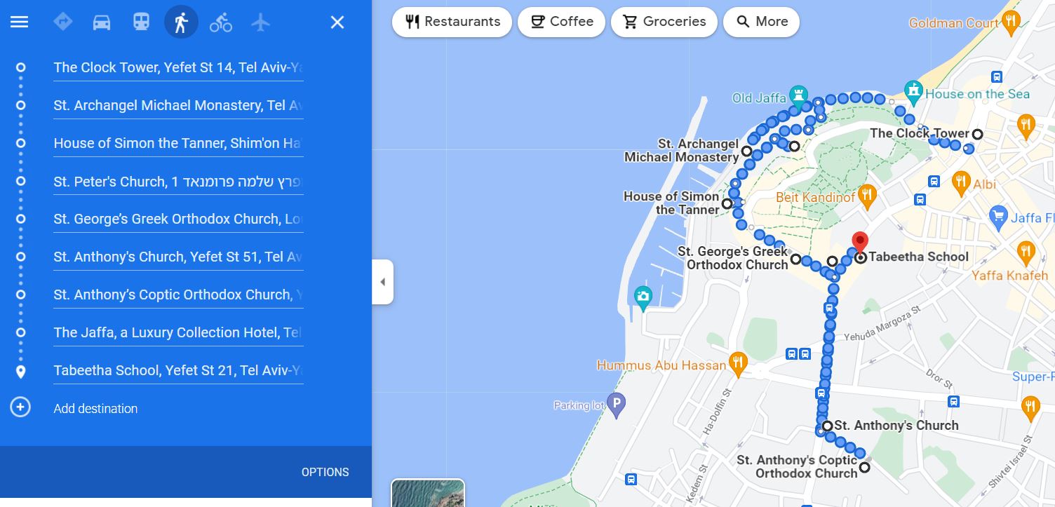
Starting at the Ottoman clocktower built in 1900 to celebrate 25 years of the rulership of Abdul Hamid II, the 34th Sultan of the Ottoman Empire and the last Sultan to exert effective autocratic control over the fracturing state. The first church to visit is the St. Michael’s Greek Orthodox Church.
Continuing to the “House of Simon the Tanner” (שמעון הבורסקאי) at the Armenian Christian Zakarian family and hearing about the story of Petrus who went from Jaffa to Caesarea, the location of the Roman headquarters in the 1st century CE, to convert Cornelius, a Roman pagan soldier. This was the first conversion of a non-Jew to Christianity. Two other sites identified with Simon the Tanner are the Franciscan Petrus church and the Russian Petrus church in Abu Kabir.
Moish Maoz will guide us in the Franciscan Saint Petrus church. We will start at the crusader chapel, built on the ruins of a byzantine monastery, by Louis the IX of France who led the 6th and 7th Crusades in the 13th century. In the year 1217 Saint Francis of Assisi established the Franciscan order in Israel, which in 1342 became Custodian Terra Sancta. In 1799, the Franciscans hosted Napoleon who was visiting his injured soldiers after the lost battle in Acre. At the end of the 19th century, a modern church was built with the help of the Spanish monarchy. The church is dedicated to Petrus and faces West, the Sea, unlike most churches that face East. This is related to the fact that Petrus went from Jaffa to the West to preach Christianity; Petrus was crucified in Rome and the angel who addressed Petrus in his dream came from the West. We will see the Black Madonna, a gift from Poland.
Saint George’s church serves the vibrant community of circa 5,000 Greek Orthodox. The compound is comprised of a monastery, a church and a large courtyard which serves the scouts. The church is dedicated to Saint George, born in the 3rd century. He served as an officer in Caesar Diocletianus’ army and saved the city of Lydda (לוד) by killing a dragon who wanted to destroy the city. Saint George is the 4th sacred saint in Christianity after Jesus, Mary and John. George converted to Christianity which was a forbidden religion at the time of Diocletian. He was tortured to death on the wall of Andromeda in Jaffa and is buried in Lydda. He is depicted on the Iconostasis to the right of the prophet Elijah.
Our next stop is the Catholic Franciscan Saint Anthony church on Yefet Street 51 which offers several religious services on Saturdays and on Sundays. St. Antony church and St. Petrus church are the two Franciscan churches in Jaffa. The church is dedicated to Anthony from Padua, Italy, who was a Portuguese Catholic priest and friar of the Franciscan Order. He is known as the most celebrated of the followers of Saint Francis of Assisi and is the patron saint of Padua and many places in Portugal and in the countries of the former Portuguese Empire.
There is a large educational center of Terra Sancta. We are going to be present at the Messe and will enjoy the liturgics. The ceremony includes the drinking of wine and the eating of the Communion, representing Jesus’ blood and body, offered solely to Catholics.
Hopefully we are going to be lucky and be allowed to enter the St. Anthony Coptic Church in Jaffa, a unique opportunity to visit a church that is usually inaccessible to the public. There are 5 monks, dressed in their unique traditional clothing, with Father Michael as the sole monk. The Coptic Christians arrived in Jaffa following the invasion of Ibrahim Faha (1831-1840) from Egypt and established the church in 1855. There is a strong connection between Egypt and Jaffa (Jebaliya in Jaffa is named after the neighborhood in Gaza and Abu Kabir, established in 1836, is named after the city Abu Kabir in the Egyptian delta; oranges form Jaffa were exported to Egypt). The compound is comprised of a monastery, a guest house, a church and a previously well-kept orange orchard. During Easter 10,000 Copts from Egypt visited Jaffa (in Egypt there are approximately 10 million Copts). The church is dedicated to Antonius the founder of monasticism at the end of the 3rd century in Egypt. The church is orthodox and belongs to the Monophysite churches who believed that Jesus had only a single “nature” which was either divine or a synthesis of divine and human.
En route to the five schools clustered on Jeffet street, we pass King Faisal’s bridge (Jeffet 42) which was built by the British mandate and enabled traffic above the Gaza Road that connected Jaffa with Gaza. Faisal was the ruler of Iraq appointed by the British.
The educational institutions include a) Secondary Terra Santa; b) Saint Michael school of the Greek Catholics; c) the school of Sisters of St. Joseph of the Apparition which was later turned into the French hospital named after Louis IX and nowadays is a luxurious compound; d) Le Collège des Frères built in 1882 and is part of the French La Sallian educational institutions, the school is operated by the French embassy and the Israeli Ministry of Education. There was rivalry between the Salian Franks and the Italian Salesians; e) Scottish Tabeetha School built in 1863.
The kind hospitality of the Jaffa Assembly will lead us to the Protestant Anglican cemetery which is nowadays well preserved. The land for the cemetery was purchased in March 1842, two months after the arrival of Bishop Michael Solomon Alexander in Jerusalem. In those days, Jaffa was still surrounded by a wall[1]. On the east side of Gaza Road, stretched along the wall’s ditch (Jeffet Street today), was a barren hill on which the cemetery was established, along with other Christian institutions. Two famous people are buried in this cemetery: a) Dr. Anthony Hodgkin, a British physician. He accompanied Moses Montefiore to Palestine in 1866, where he contracted dysentery and died in the same year. He is considered one of the most prominent pathologists of his time and a pioneer in preventive medicine. He is now best known for the first account of Hodgkin’s disease, a form of lymphoma and blood disease.; b) the British General Edward Thomas Mitchell who took part at the Battle of El-Medjdel, a skirmish between Ashdod and Gaza, possibly (judging from the name) near al-Majdal Asqalan, on the 15th of January 1841.
Our last site before lunch is going to be the Scottish Tabeetha School. In 1863, Jane Walker–Arnott, the eldest daughter of a Glasgow University professor, founded the school to give the girls of Jaffa a measure of dignity and independence in an oppressive society. In 2013, the school celebrated 150 years.
We will drive to Abu Kabir and park in the large parking lot (Ben Zvi Street corner Tel Giborim Street).
Petrus Provoslavian orthodox church in Abu Kabir, is dedicated to Petrus and Thabeeta whom Petrus revived. This is one of the Russian compounds in Israel, situated on the main road between Jaffa and Ramle and from there to Jerusalem – the route of the pilgrims which included St. Petrus church in Jaffa, Joseph of Arimathea (Yosef Haramati) in Ramle who donated his burial cave to the crucified Jesus, and Jerusalem and Bethlehem. Brother Constantine Nurov identified this site as Thabeeta’s burial place, which eventually led to the purchase in 1874 of 32 dunams by Antonin Kapustin, a monastic clergyman of the Church of Russia. In the 70s of the 19th century, the noted French Orientalist and archaeologist Charles Simon Clermont-Ganneau identified 34 Jewish tombstones with Hebrew encryption. The tombstones were transferred to Europe and in 1975 Dr. Zvi Ilan managed to get 7 of the tombstones back which are nowadays on display in the Museum of Jaffa, near the Saraya building in the Old City of Jaffa.
At the Russian compound in Abu Kabir there is the burial cave of Thabeeta, a cemetery and the church. The church was erected in 1894 and belonged to the few churches of the “White” Russian orthodox order (such as the Church of St Alexander Nevsky in Jerusalem). The Russian KGB operated extensively in this church, one of the Russian spies being the Israeli colonel Israel Bar who was active in the 60s of the 20th century and was sentenced for 10 years in prison.
The aedicule of Thabeeta has an encryption in several languages, including Greek, Georgian, Latin, English, Hebrew, Arabic and Cyrillic.
The tomb of Thabeeta is a cave in the kurkar (calcareous sandstone) ridge and resides in a beautiful garden with plants, trees and peacocks, the latter being a symbol of eternity in Christian belief.
The church is richly decorated with a beautiful iconostasis and paintings in the aisles depicting Petrus with the angel Michael; Jesus washing the feet of his disciples prior to Last Supper; Jesus giving Petrus the primacy at Tabgha, by the Sea of Galilee; Peter’s triple rejection of Jesus as commemorated at the Church of Saint Peter in Gallicantu on Mt. Zion, Jerusalem. Another painting shows Petrus’ crucifixion in Rome with his head down.
[1] http://www.academia.edu/14694571/The_Anglican_cemetery_in_Jaffa
IBEX - ISRAEL’S BEST EXPERIENCE


Israel: Center
+ Ha’Nadiv Gardens and Nature Reserve, Alexander Stream and Agamon Hefer
VIEW IN PDFBy Racheli Kreisberg4 November, 2021
Preparations in advance: Good walking shoes, hat, sun lotion, water, map of Northern Sharon area and of Zihkron Yaakov area
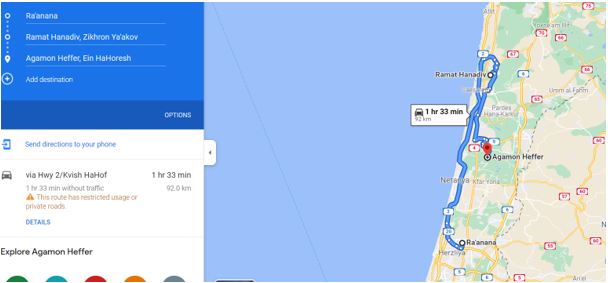
Drive from Center to the Hanadiv Gardens via the Coastal Road (#2)
On the way to our destination, we are driving through the Sharon Plains. The geographic borders of the Sharon are the Yarkon River in the south, the foothills of the Samarian mountains in the east, Alexandria stream (North of Beit Yanay) in the north and the Mediterranean Sea in the west. The Sharon is named after the dense forest which ones populated this area.
Road #2 is located between the Western and the Central Kurkar ridge (and Road #4 is located between the Central and the Eastern Kurkar ridge). The Kurkar ridges along the coastal plain of Israel are composed of alternating calcareous aeolianite (kurkar) and paleosol (hamra) units. In Israel there are roughly speaking 3 parallel Kurkar ridges. Kurkar is formed by lithification of sand dunes under Mediterranean weather conditions (long dry summer and short winter. The origin of the sand along the coast is from the Nile. The sand is deposited along the seashore during a period of falling sea levels to form a foredune. Upon rising of the sea, the foredune erodes. During a second phase of falling sea level, the 1st foredune is restored and a second foredune is formed in the prograding shoreline. Again, upon the rising of the sea, the newer foredune erodes. In Israel, 3 kurkar ridges result from 3 periods of falling and rising sea level.
Park at Ha’Nadiv garden parking area for a fee
Breakfast near the parking area
Walk through the Nature Reserve following the green path (Vultures Trail), the red path (Manor Trail) and finally the blue path (Spring Trail)
The circular green path (the Vultures Trail[1]) is the longest and most challenging of the three trails in the Nature Park. Recommended for skilled hikers, this path traverses a wealth of natural landscapes interspersed with observation points, a prehistoric cave, and an acclimatization cage for birds of prey.
From the observation point on the green trail, walk towards the trailhead, and then continue to the red path (The Manor Trail[2]). The Israel National Trail marking (orange-blue-white) may also be seen at the beginning of the trail.
Return to the trailhead and then onto the blue path (The Spring Trail[3]).
[1]https://www.ramat-hanadiv.org.il/en/routs/the-vultures-trail/
[2]https://www.ramat-hanadiv.org.il/en/routs/the-manor-trail/
[3] https://www.ramat-hanadiv.org.il/en/routs/the-spring-trail/
Walk through the Hanandiv Gardens to the Ma’ta’im restaurant
Dairy lunch at Ma’ta’im restaurant (Kosher)
Drive from Hanadiv Gardens to Agamon Hefer
Agamon Hefer is situated near Alexander stream, not far from Ein Hahoresh. The easiest way to get there is by entering “Agamon Hefer” into Waze which will take you to Hefer junction where you turn east following a dirt road along Alexander stream for 3.5 km. Park near the Love Tree Bridge (גשר עץ האהבה).
Tour the Agamon Hefer (circular tour)
Cross the bridge (גשר עץ האהבה), turn right, and walk along the Alexander Stream till you reach the entrance to Agamon Hefer. Alexander stream is one of the largest in the Sharon streams. It is about 45 km long and drains a large area of about 550 square km. The origin of the stream is in the Samarian mountains, between Mount Gerizim and Mount Eibel. It enters the Sharon plains between Kochav Yair and Taibeh and flows into the Mediterranean Sea between Mikhmoret and Beit Yanai. Walk towards the viewpoint and continue walking around the pools enjoying nature. Agmon Hefer ponds used to be the fishponds of Kibbutz Ein HaHoresh which were turned into a green park. Today you will find attractive walking paths, bridges, and a variety of observation huts, which are designed in such a way that one can see the birds. Among other things, you will see common falcon, magellan, spotted butterfly, white-breasted kingfisher, common squid, finch, snail and more – with pictures of the species that can be seen in each hut.
Drive back to Center
IBEX - ISRAEL’S BEST EXPERIENCE



Israel: Center
+ Rosh HaAyin Izbet Zarta (Eben-Ezer)
VIEW IN PDFRosh HaAyin Forestand Khirbet Dawir – round trip.
By Racheli Kreisberg 23 December, 2020
Preparations in advance: Bible (Book of Samuel), Good hiking shoes, water, trekking poles during winter to avoid slipping on wet rocks.
Drive from the Center (Tel Aviv, Sharon Area) to Izbet Zarta עזבת צרטא in Rosh HaAyin
Visit Izbet Zarta (Eben-Ezer)
There is not a huge amount to see at the site, but here a piece of pottery containing an ancient Hebrew writing exercise was found: some of the earliest Hebrew script ever to be discovered. The line written at the bottom proved to be the most interesting, as it consists of the letters of the ancient Hebrew alphabet. Researchers believe that the entire “document” is a writing exercise composed by a pupil who practiced his letters by writing out the alphabet of his time.It is now in the Israel Museum in Jerusalem.
Izbet Zarta is tentatively identified as being the site of biblical Even Ha’ezer, where the fateful battle between the Israelites and the Philistines as described in the book of Samuel took place. On defeating the Israelites, the Philistines captured the sacred Ark of the Covenant, causing the Israelites great consternation. The location of the settlement near Tel Afek would seem to fit with the biblical description.
The battle appears in the Books of Samuel in two narratives:
- In the first narrative (1 Samuel 4:1–11), the Philistines defeat the Israelites, even though the Israelites brought the Ark of the Covenant onto the battlefield hoping that it would bring them a divinely assured victory. As a result of the Philistine victory and the Ark’s presence on the battlefield, it was captured by the Philistines, and not returned until many months later (1 Samuel 6:1–2).
- In the second narrative (1 Samuel 7:2–14), the Israelites defeat the Philistines, after Samuel has offered a sacrifice. Samuel puts up a stone in memorial and names it Eben-Ezer. This monument is referred to in the hymn “Come Thou Fount of Every Blessing”.
The remains of a large building surrounded by smaller houses and pits that were used as granaries for storing wheat can be seen. The pits were sealed off every winter to protect their contents from damage by rain. The early settlers lived off agriculture, growing wheat and raising goats and sheep. The structure of the building is typical of the period and is of the type referred to as a four-room house.
Drive to Rosh HaAyin Forest
Hike/Walk in Rosh HaAyin Forest, including circular walk of Khirbet Deir
The Rosh HaAyin Community Forest extends over an area of around 1,050 dunam and provides a green belt for the northern fringes of the new neighborhood of the town.The Raba River, one of the tributaries of the River Yarkon, runs through the length of the forest.
We can set off on foot to see the forest flowers and the Wildflower Trail. We walk round the gate and continue along the main forest trail, which leads us to the beginning of a footpath that continues for a kilometer. There is a signpost at the start of the path, and the route is marked in red all the way along.
This path, which provides pedestrian access to the Neveh Afeq neighborhood, is circular: it climbs up the hill, before taking us back down to our starting point. It is beautiful at all seasons of the year, but especially so when the flowers are in bloom.
At the top of the hill, there are the remains of an ancient settlement dating back to the Byzantine period, now known by the Arabic name of Khirbet ad-Dawir. The remnants of several buildings can still be seen. To the east of the site, a square cistern has been hewn into the rock and plastered, and visitors should take care not to stumble over any of the other holes or obstacles at the site.
The KKL-JNF observation point offers a view of the entire region: to the east we can see the hills of Samaria, which are easily identifiable as they are almost totally bare, with only a few trees remaining to remind us that they were once the site of natural woodland. To the north we can see Kafr Qasem and the Trans-Samaria Highway, with the city just visible to the south. From here, we descend the marked path until we reach the dirt road we crossed earlier.
Picnic in the forest
Drive back home
IBEX - ISRAEL’S BEST EXPERIENCE


Israel: Center
+ Kedoshim Forest, Martyrs’ Forest, Jerusalem Mountains
VIEW IN PDFCarmila Mountain and Kisalon Riverbed.
By Racheli Kreisberg 1 December, 2020
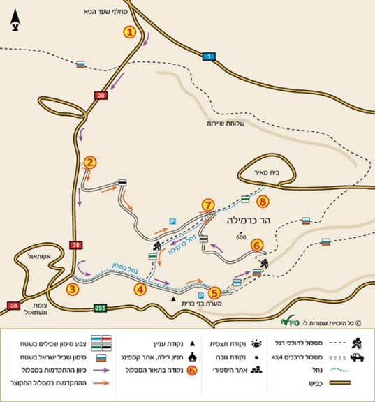
Enjoy a circular 6-km hike in the green Kedoshim forest (Martyrs’ Forest), with a climb on mountain Carmila and a long descent through the rocky Kisalon wild riverbed .
We started our hike in the Kedoshim Forest at the Anne Frank Memorial, right off of highway 38 and parked near the Bnei Brit memorial cave. We paid our respects at the Simon Wiesenthal Memorial at the foot of the “Simon Wiesenthal Path”.
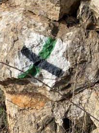
We looked for the sign of the blue path and began to hike up the Carmila Mountain. The ascent was not very difficult at first. The trail (which is also part of the Israel Trail) is completely tree lined, and although not flat, the climb is not steep.
As the path sneaked back and forth, the hill became noticeably steeper. The views at each turn were magnificent. Winter wildflowers poked out of every crevice. We stood on the last part of the path that was truly in the forest, surrounded by trees. A few more steps, and we would be up the top on a biking and walking path that encircles the peak of the mountain.
Here, we turned left onto the black marked path and followed it halfway around. This trail was flat and wide, easy to walk on. Looking down there are fantastic views of the area’s surroundings – rolling green mountains up to the cities in the distance.
We turned left onto the green trail and walked on a variety of rocks, flat, with a diagonal slant or just broken up. We descended the Carmila riverbed into the valley below. It felt like walking through a river, but there was no river in sight. The strange rock formations that we walked on were clearly shaped by water. Moss and algae grew everywhere. And of course, the flowers.
Some of the rocks were methodically arranged by nature into the shape of an amphitheater. Others seemed perfectly poised in the valley for a hideaway picnic. But during the entire walk, we remained fascinated as we turned each corner, ready to see what surprises nature held in store
After we walked by a decaying tree trunk filled with clover and moss, we came to the end of this part of the trail. Tall trees climbed up in front of us, and we passed through them back onto the main road – the red trail
At the very beginning of the hike, we had driven down this road toward the trailhead. I was happy to get a chance to walk along this path. When we drove by car, I felt like we were zipping past all the beauty. I was right to want to slow down – it was less rough than the other trail, but no less splendid.
We ended our walk at the Anne Frank memorial designed by Piet Cohen
A kilometer or so on this road and we were back at our car.
IBEX - ISRAEL’S BEST EXPERIENCE



Israel: Center
+ Sidni Ali Beach and Mosque
VIEW IN PDF3 hours trip (easy).
By Racheli Kreisberg 20 February, 2021
Preparations in advance: Good hiking shoes, water
Park around Yigael Yadin street #8 (Sidni Ali Mosque parking area) and walk north on the limestone cliff.
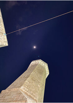
Descend towards the Sidni Ali beach, pass the “Artistic House” of Nissim Kachalon (Nissim’s Cave-House) on the Apollonia Beach. Nissim, who is also known as the “Herzliya Hermit”, built this place with his own two hands.
Continue walking north, passing on the foot of the Tel Arsuf/Apollonia archaeological site which can be seen above. The beach is covered with boulders next to the Tel Arsuf cliff and requires careful movement between the stones. The stones are intended to protect the limestone cliff from the sea waves that cause its collapse. The walk is not difficult because the stones are nicely arranged and next to them is a narrow path. Look at the remainders of some of the Arsuf fortifications.
Walk till you reach a little creek that will enable you to ascend to the old and abandoned Ta’as factory Nof Yam/Tel Arsuf. Ta’as Nof Yam was a military factory, established in the 1950s, in which weapons and explosives were manufactured. In the year 1991, a huge explosion occurred that burnt the factory down and polluted the environment with toxins and hazardous materials and contaminated the groundwater. The place is closed to wanderers. Be careful.
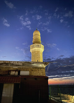
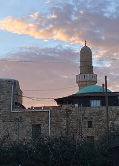
Walk south towards the Sidni Ali Mosque and visit the mosque. According to Muslim tradition, one of the commanders of the Muslim army, Ali Ben-Aleim, the seventh grandson of the Khalif Omar Ibn El Khatib, who died in 1081, is buried here. The place served as a pilgrimage site, especially during the Crusader period. According to Mujir al-Din, the building and well were constructed in the year 1481 during the times of the Mamelukes . It attracted Arab and Bedouin residents of the area who also came from Samaria to judge between a man and his friend in a test that took place at the site by a miraculous black stone, that stone was positioned in the wall near the tomb und used to check whether a person was telling the truth. The person had to stand, with his eyes covered a few steps in front of the tomb. and move towards the tomb with an outstretched arm. In case his hand touched the stone, it was a sign that he was talking the truth, and if not it shows that he was lying and he was forced to pray. Nowadays, there is no stone. A large part of the Mosque was built during the Ottoman period, a time during which there was a small harbor the Apollonia anchorage, from which watermelons were shipped from Palestine to Egypt.
IBEX - ISRAEL’S BEST EXPERIENCE


Israel: Center
+ Ben Shemen Forest (Modi’in) Area
VIEW IN PDFBen Shemen Forest, memorial plaque for Mr. and Mrs. Kuiper Heuvelink, The Hasmonean Tombs, Commemoration site for the fallen IDF soldiers (Post 219).
By Racheli Kreisberg 6 February, 2021
Preparations in advance: Good hiking shoes, water
Directions toBen Shemen Forest
- From Highway 1 turn east at Ben Shemen Interchange to Maccabim and Re’ut (443)
- From the north, from Highway 6, exit at Ben Shemen Interchange (444) towards Tel Hadid
- From Jerusalem, drive on Highway 443 towards Ben Shemen
Drive and/or walk in the Ben Shemen Forest
The forest has 6 entrances, each with a big sign that has a map: Gate 1 – Herzl Gate, near Gimzo; Gate 2 – Tel Hadid Gate, at the entrance to the Quartermaster Corps Memorial; Gate 3 – Mitzpe Modi’in Gate; Gate 4 – Kedumim Gate, near Ne’ot Kedumim Park; Gate 5 – Maccabim Gate, near the Tombs of the Maccabees; Gate 6 – Monks Valley Gate .
Ben Shemen Forest is the largest forest in Central Israel, with 22,000 dunams of forested areas, which offers a diversity of hiking routes, bicycle paths, picnic areas, archaeological sites, a profusion of wildflowers in winter and spring. Ben Shemen Forest exemplifies the Zionist dream and its realization. Theodore Herzl understood the essence of the redemption of the land and said, “When the plow returns to the strong hand of the Jewish farmer, the Jewish problem will be solved”. KKL-JNF, turning this dream into reality, began purchasing lands in Israel in 1907 and proceeded to prepare them for afforestation and for inhabitation. The Ben Shemen Forest was the first and the largest afforestation initiative in the history of the State of Israel.
KKL memorial plaques of Mr. and Mrs. Kuiper Heuvelink – the Dutch connection
In the Ben Shemen forest, there is a plaque in memory of Mr. Frits Kuiper (1898-1974) and Mrs. Maaike Anna Kuiper Heuvelink (1901-1991) (https://www.jnf.nl/wp-content/uploads/2014/09/lijst_met_parkenwouden.pdf).
Frits Kuiper, was the son of Abraham Kornelis Kuiper and Henriëtte Sophie Muller. His father and grandfather were Mennonite ministers in Amsterdam. He was a member of the Dutch Christian student movement executive committee. During World War II (1940-1945), he continued contacts with the illegal Vrij Nederland (Free Netherlands) paper and published some issues of De Vrije Alkmaarder. Following his call to serve in Amsterdam in 1945 he became involved with a Roman Catholic leader and a Jewish rabbi in the publication of De Stem van Israel (The Voice of Israel). From 1945 to 1947 he served as director of the study center Vrij Nederland after which he served as minister until 1963.Kuiper was a Zionist, not only because of Israel but as a Christian with Messianic expectation of the new kingdom. He understood his calling as pastor to proclaim the message of the Old and New Testament within the context of Messianic expectations.
The Hasmonean Tombs
A little before the Tombs of the Maccabees there is a stone building where, according to tradition, Matityahu, son of Yohanan the High Priest and father of the Maccabees, is buried. The road proceeds to a small hill on top of which there are two rows of graves and a small burial cave. There are nine tombs carved in the bedrock, and each of them has two bases. Tradition attributes these graves to the Hasmoneans and the Maccabees, but they stem from the Byzantine period.
“In those days arose Mattathias the son of John, the son of Simeon, a priest of the sons of Joarib, from Jerusalem, and dwelt in Modi’in” (I Maccabees 2:1). When Judah and his brothers died, they were buried in Modi’in, in an ancestral tomb. But where is Modi’in? Today, it seems strange to even ask such a question. There is a large city in Israel known as Modi’in, in whose vicinity lie towns with names like Matityahu, Hashmonaim and Maccabim, as well as a historical site known as the Tombs of the Maccabees.
The connection between ancient Modi’in and its modern-day counterpart is not so simple. The identification is based on several sources. One of them is the book of Maccabees. Following the death of the High Priest Jonathan, who had been betrayed and captured by the Seleucid ruler Diodotus Tryphon, we read: “Then sent Simon, and took the bones of Jonathan his brother, and buried them in Modi’in, the city of his fathers… Simon also built a monument upon the tomb of his father and his brothers, and raised it aloft for all to see, of hewn stone behind and before. Moreover, he set up seven pyramids, one against another, for his father, and his mother, and his four brothers. And in these he made cunning devices, about which he set great pillars, and upon the pillars he made all their armor for a perpetual memory, and by the armor ships carved, that they might be seen by all that sail on the sea. This is the tomb which he made at Modi’in, and it stands yet until this day”. (I Maccabees 13:25-30). According to Maccabees, Simon built a magnificent burial complex, with seven pyramids atop the tombs and carved pillars depicting weapons, armor and ships. But the interesting part of this passage for our purposes is the ending: “that they might be seen by all that sail on the sea” and “until this day”. However, we have not found any remnants of these seven adjacent pyramids anywhere in Israel.
In the Onomasticon’s entry for Modi’in, Eusebius writes: “Village near Diospolis. Home of the Maccabees where their tomb is pointed out even now” (Onomasticon 132:16-17). We see from here that even centuries after the destruction of the Second Temple, the tombs of the Maccabees were still plainly visible in a village near Lod. The most important piece of information in support of this identification of Modi’in is the Madaba Map. In this ancient mosaic map, dated to the sixth or seventh century CE, the village of Modi’in is accompanied by the following label in Greek: “Mōdeeim which is now Mōditha, whence were the Maccabees”. West of the village lies the city of “Lōd”; to the east lies the village of “Bethōrōn”; to the south lies “Bētoannaba”; to the northeast lies “[Kaph]eruta”; and to the northwest lies “Aditha.” All of these locations are familiar to us. Lod and Beth-horon (today Beit Ur al-Tahta) are well-known places. Bētoannaba refers to Innābe, an Arab village that was destroyed in the War of Independence. Its name is preserved today in the form of Nachal Anava and the Anava Interchange. Kapheruta apparently refers to Khirbet KafrLut, located east of Kfar Ruth. Finally, Aditha refers to al-Haditha, an Arab village, now known as the archaeological site Tel Hadid, inhabited until 1948. All of this information essentially corroborates the notion that ancient Modi’in and modern Modi’in are located in the same region.The precise location of ancient Modi’in within the greater Modi’in area has not been determined conclusively.
Commemoration site for the fallen IDF soldiers in the Modiin region
There is a monument commemorating the soldiers who fell in the battle at Post 219 during the War of Independence. That battle took place during the second truce between the Jordanian Legion forces, local fighters and soldiers from the Kiryati Brigade, on September 24, 1948. Post 219 is located near today’s Highway 443, in the Ben Shemen Forest near Hirbat Ha Gardi (the tomb of Sheikh Arbawi, now identified by the ultra-Orthodox as the tomb of Matityahu the Priest) and the Maccabim tombs, and west of the Palestinian village of Media. The place was occupied in July 1948 as part of Operation Danny, and soldiers from Company A of the 142nd Kiryat Battalion were stationed to guard the place. At the dawn of September 24, 1948, cannon and machine gun fire was opened on post 219. Soon an attack began on the post and an unorganized retreat to the home front began. Only in the afternoon did reinforcements from the Kiryati Brigade arrive and reoccupy the checkpoint. The bodies of the fighters desecrated by Media residents were found at the site. 23 fighters were killed in the battle.
IBEX - ISRAEL’S BEST EXPERIENCE



Israel: South
+ Northern Dead Sea Region (Good Samaritan, Qasr El Yehud, Deir Hajla Monastery, Lower Og Wadi)
VIEW IN PDFGood Samaritan, Qasr El Yehud Baptism Site, Deir Hajla (Monastery of St.Gerasimus), Lower Og Wadi.
By Racheli Kreisberg 12 December, 2020
Preparations in advance: Reserve at the sites you wish to visit (i.e., The Good Samaritan Museum, Qasr El Yehud)
Drive from the Center (Tel Aviv, Sharon Area) to the Good Samaritan
Visit the Good Samaritan museum
Phone: 02-6338230, Email: good-shomroni@npa.org.il
The museum is located in an ancient building from the Ottoman period which was originally built as a travelers’ inn. Its six halls have been restored. On display in the museum are archaeological remains, including a wealth of beautiful mosaics from the Byzantine period. One wing of the museum is devoted to the story of the Samaritan community, their history and customs.
The Parable of the Good Samaritan: Lk 10:25–37 NIV – The Parable of the Good Samaritan – On – Bible Gateway
The Good Samaritan depicts the final scene in the parable of the Good Samaritan (Luke 10:25-37) in which the Samaritan stopped to help a traveler who had been attacked by robbers. In this painting which shows a Samaritan wounded man being carried to the entrance of an inn where he will be tended, Rembrandt defines the key roles that the doorway was to play in his art, either between two states of the drama or two different states of existence. Viewed in this way, the doorway may be seen as the visual equivalent of a new chapter heading
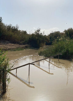
Qasr El Yehud baptism site
The site where, according to tradition, Jesus was baptized by John the Baptist
Drive to Deir Hajla
Deir Jajla monastery (Monastery of St Gerasimus)
One of the earliest of the more than 70 monasteries in the Judaean desert, is named in honor of a pioneering monk who is usually depicted with a pet lion.
Drive to Lower Og Wadi
Circular Hike Lower Nahal Og (5 km for fit walkers, 1-2 hour walk)
We recommend walking our route in a clockwise direction: from the parking lot we follow the dirt track that descends northwards and takes us directly down to the broad bed of Nahal Og. The route is indicated by red trail markings. At this point the riverbed is wide and very large – evidence of the powerful floods that sometimes sweep down – and the streambed is full of desert plants. Down in the riverbed we turn west (to the right) and head for the entrance to the gorge, following the green trail markings. From this point on our route will lead us up dry rocky waterfalls. This section of the riverbed, which is about 1.5 kilometers long, was referred to by local people in the past as Wadi al-Asla. As we progress, the ravine grows steadily narrower, until it is no more than two meters in width in some places. The walls soar dozens of meters above us on either side. For the most part walking is easy, but we still have three waterfalls to cope with: the first is eight meters in height, the other two slightly lower. But even after we successfully negotiate the waterfalls, we cannot relax yet. Further along, our way is barred by a waterfall 1.5 meters in height. Most hikers will manage to make their way over it with the help of a step on the left, but the less tenacious may perhaps require a little assistance. As we emerge from the ravine, the riverbed broadens out. Here we leave it and turn right on to a black-marked dirt road, which, though short (it is only about 400 meters long), is rather steep. After just a few steps we turn right once again on to a blue-marked trail that leads us towards Kibbutz Almog, which is clearly visible from here.
IBEX - ISRAEL’S BEST EXPERIENCE




Israel: South
+ Jordan Valley (Moshav Argaman, Biq’a Memorial, Mevo’ot Jericho)
VIEW IN PDFJordan Valley, Moshav Argaman goat cheese farm, Sandal Archaeological site, Memorial Monument Ha-Bik'a, and Mevo’ot Jericho 1st century aqueduct and artificial water pool
By Racheli Kreisberg 29 September, 2021
Preparations in advance: • Good walking shoes, hat, sun lotion, water, map of Jordan Valley • The tour is in Area C of the Palestinian Authority. Carefully follow the routes cited below and do not enter Area A
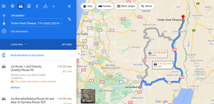
Drive from Jerusalem to Moshav Argaman
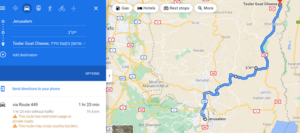
North on #50 till Qalandiya junction, then east on Road #45 till till #60; continue on #60 passing Sha’ar Benjamin industrial zone on your right. Turn right on #457 towards Alon Road/Road 458 fork. Continue on Road #458 till Teibe Junction, turn east on Road #449 and descend to Jordan River through Tareq Abu George Road (#449) (formerly Road #3). Turn left towards Yita”v. At the T-junction turn right towards Road #90 and the Palestinian village Al Ouja. Turn North on Road #90 till you reach Moshav Argaman.
Moshav Argaman is named after Colonel Arik Arye Zidman Regev (16 February 1933 – July 26, 1968) and Major Gad Manela (9 January 1946 – 26 July 1968), two Nahal commanders who were killed there in a clash with Arab militants. Col. Arie Regev, commander of the valley, and Captain Gad Manela, pursued squads who crossed the Jordan River and entered the West Bank to attack IDF forces. In the pursuit that took place on 26 July 1968, Regev and Manela were killed. In this pursuit, eight terrorists were also killed, and one was wounded and captured.
Frieda and Avi Tessler arrived in Moshav Argaman in 1972 as part of their military service in the Nahal. They grow goats and sheep and produce a large variety of homemade cheeses. Frieda organizes cheese-related activities and Avi guides through the sheep pen.

Drive to the viewpoint just outside Moshav Argaman
Exit the outer fence of Moshav Argaman. On your left there is a small elevated “hill” with a dirt road. Park your car on the left-hand side of the road.
Sandal Archaeological site at Moshav Argaman
This archaeological site is one of the 39 “Gilgalim” (circles in Hebrew) that were mentioned in the bible and exist only in the Jordan valley and on the mountain ridge. These sites served the People of Israel as places of worship, legal trials, gatherings, and even wars, during the Israelite Settlement Era (12th-10th century BCE) as well as during the Israelite kingdoms of David and Solomon and during the time of the prophets Hosea, Amos, Micha and Nechemia (9th-8th century BCE).
The Gilgalim were always situated on plateaux and they were lower than their environment. The best-known Gilgal is the place “on the east border of Jericho” where the Israelites encamped after crossing the Jordan. There Joshua set up the 12 stones which the Israelites had taken from the Jordan (Josh. 4:19–20). Other Gilgalim sites in the area of Moshav Argaman include Ma’su’a, Yafit, Tirtza river.
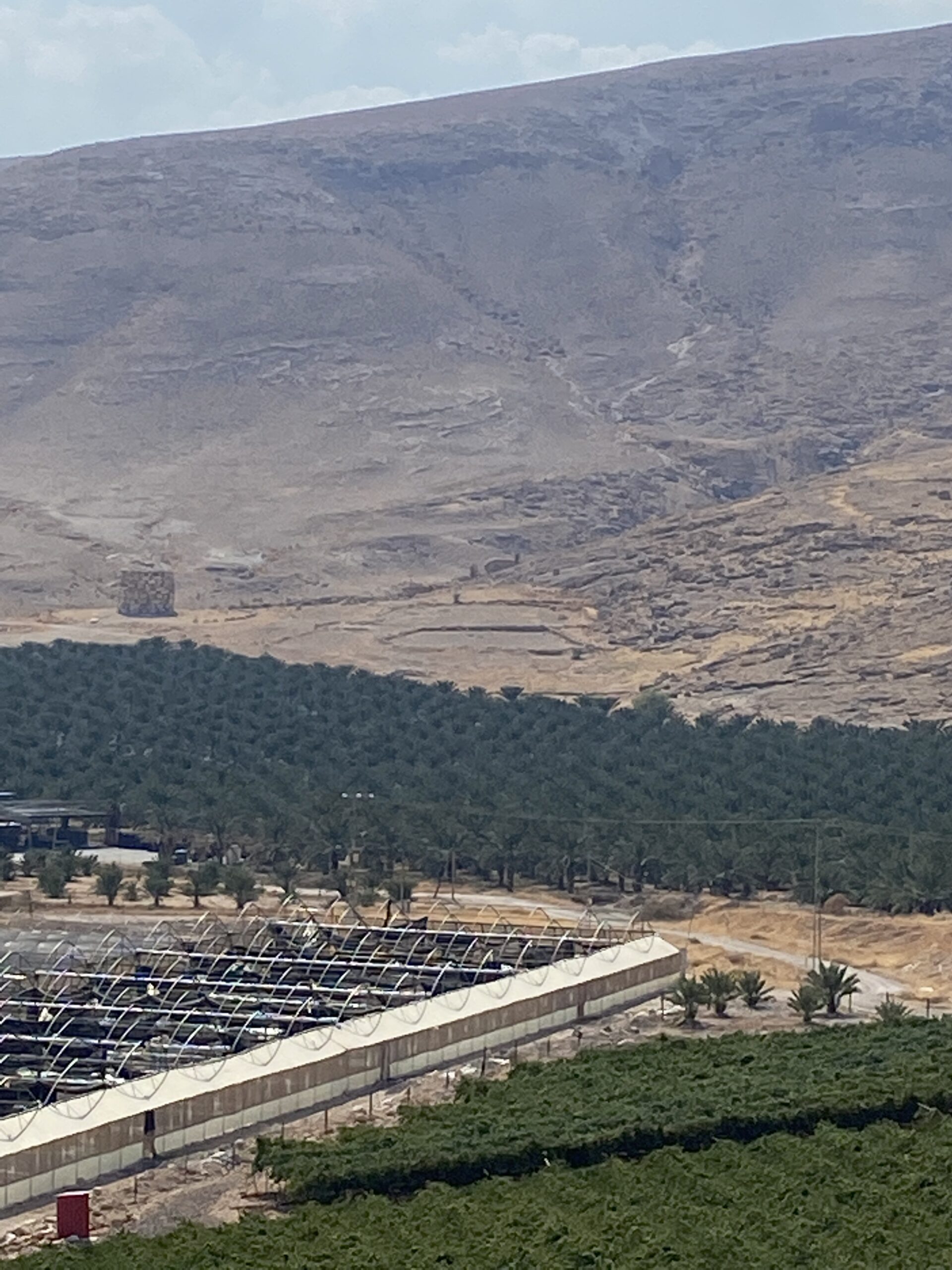
The site in Argaman is 14 dunam (80 by 200 meter) and is shaped as a foot. It was discovered in 1989 and excavated between 2003-2008 by Dror Ben Yosef from Haifa University. A large circular podium might have served for sacrifices and the path of the processions surrounds the “heel” of the sandal in a semi-circle. This is the only Gilgal site which has been restituted.
In 2009, Prof. Adam Zertal (1936-2015) suggested that the purpose of the sandal sites was to
- demonstrate ownership of the Land – “Every place where you set your foot will be yours: Your territory will extend from the desert to Lebanon, and from the Euphrates River to the Mediterranean Sea”. (Deuteronomy 11:24)
- link between the People and the Land of Israel – “I will not again make the feet of the Israelites wander from the land I gave their ancestors, if only they will be careful to do everything I commanded them and will keep the whole Law that my servant Moses gave them”. (2 Kings, 21:8)
- dominate gentiles and enemies – “You know that because of the wars waged against my father David from all sides, he could not build a temple for the Name of the LORD his God until the LORD put his enemies under his feet”. (1 Kings 5:3)
- resemble God – “The glory of Lebanon will come to you, the juniper, the fir and the cypress together, to adorn my sanctuary; and I will glorify the place for my feet”. (Isaiah 60:13)
This also explains the custom of the pilgrimage to the Temple during the holidays of Sukkoth, Passover and Shavuot, holy days termed in Hebrew “The Three Pilgrimage Festivals”, in Hebrew Shalosh Regalim (שלושת הרגלים). It could be that these festivities were carried out in ancient times in the area of the “sandal-shaped” sites.
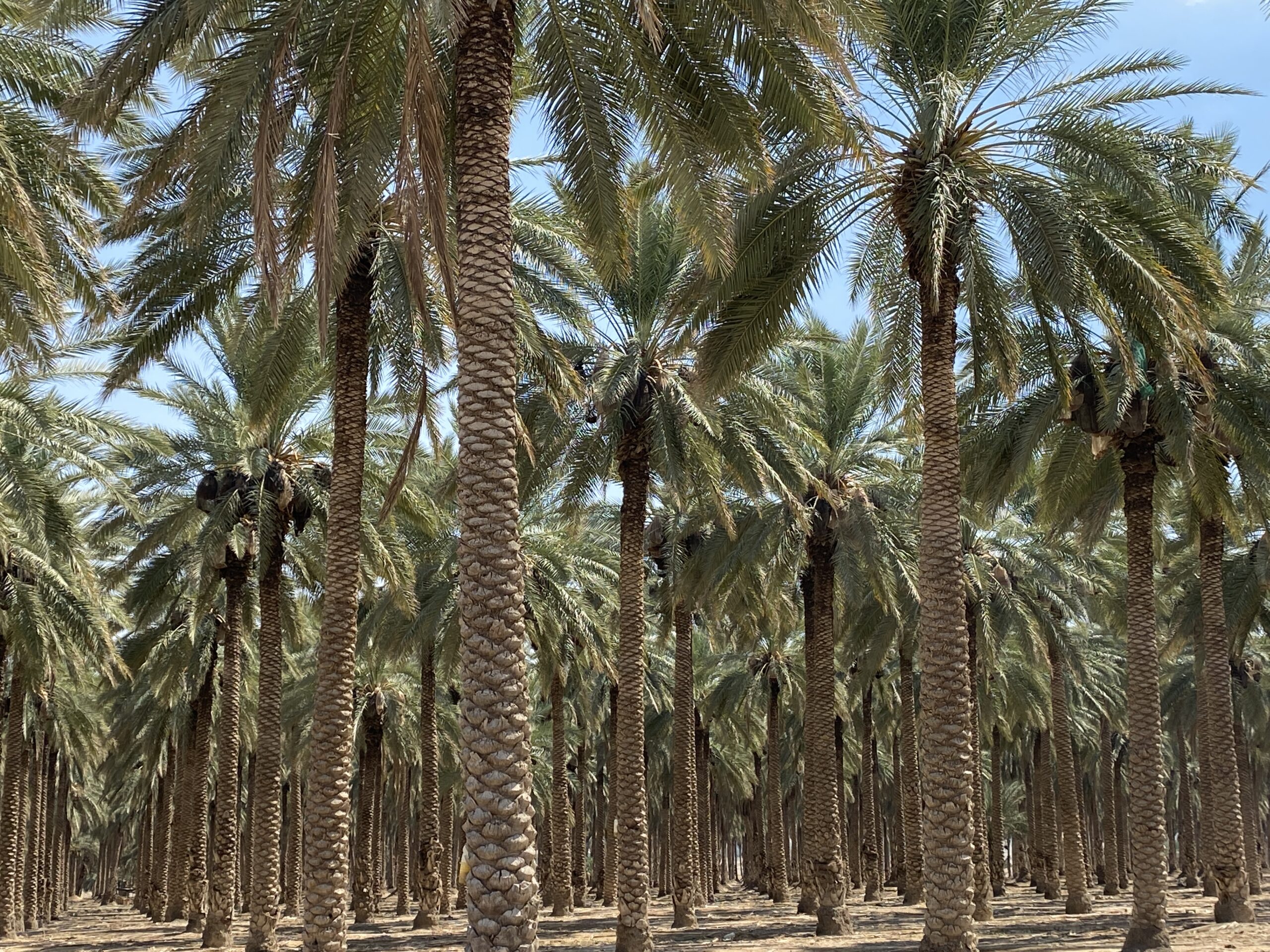
It is possible to visit the site from close by. From Road #90, turn west towards Moshav Argaman. After 400 meters, turn left (south) at the first turn and enter an agricultural dirt road among the nurseries. After 800 meters, turn right (west), pass the gate. At the end of the road, after 200 meter, exit the agricultural fields and continue westward. The Argaman sandal site is between the foot of the mountain and the western date palm orchard.
Drive to Memorial Monument Ha-Bik’a
Memorial Monument Ha-Bik’a
This memorial commemorates all the IDF soldiers who fell in the Jordan Valley area, between Beit She’an in the north and Jericho in the south, between the Jordanian border in the east and the mountains of Samaria in the west. The monument was erected at the top of a hill overlooking the area and it can be seen from a distance. The access road is paved and on its left are signs with the names of the settlements named after the fallen. A granite staircase leads to another level, with a plaza from which a statue in the shape of a giant rifle protrudes, which rises to a height of 21 meters and is made of parts of weapons and military equipment. In addition to the 366 commemorated soldiers, Rehavam “Gandhi” Ze’evi (20 June 1926 – 17 October 2001) is also commemorated here.
Next to it is a steel pillar shaped like a kind of elongated torch, symbolizing the beacons that were lit during the Second Temple period to mark the beginning of the months on the summit of the Sartava, northwest of the monument.

Drive to Me’vo’ot Jericho
Archeological remainders of aqueduct
Mevo’ot Jericho was established in 1999 and has developed gradually into a community which covers hundreds of acres. At less than one kilometer from Mevo’ot Jericho stands the ancient Jewish synagogue of Na’aran, which houses a unique and stunning mosaic floor, a Hasmonean aqueduct, and burial caves from different periods, beginning with the Second Temple era. The archaeological remainders of the aqueduct that carried water from the Ouja spring, north of Mevo’ot Jericho, to the Jewish settlement of Na’aran, can be seen. The aqueduct originates from the period of King Herod, 1st century BC.

Drive to the artificial pool of Mevo’ot Jericho
Exit the settlement and turn right (south). Turn right towards the west adjacent to the fence of Mevo’ot Jericho. Park the car in the designated area. The pool collects the rainfall of the Samaria mountains.
Artificial pool of Mevo’ot Jericho
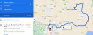
Drive back to Jerusalem via road #90 and road #1
IBEX - ISRAEL’S BEST EXPERIENCE

IBEX - ISRAEL’S BEST EXPERIENCE

IBEX - ISRAEL’S BEST EXPERIENCE

IBEX - ISRAEL’S BEST EXPERIENCE



CENTER
+ Modiin and Ben Shemen Forest,
Kedoshim Forest – Carmila Mountain and Kisalon Riverbed
By Racheli Kreisberg, December 2020
Preparations in advance: Good hiking shoes, water,trekking poles during winter to avoid slipping on wet rocks
Enjoy a circular 6-km hike in the green Kedoshim forest (Martyrs’ Forest), with a climb on mountain Carmila and a long descent through the rocky Kisalon wild riverbed .
We started our hike in the Kedoshim Forest at the Anne Frank Memorial, right off of highway 38 and parked near the Bnei Brit memorial cave. We paid our respects at the Simon Wiesenthal Memorial at the foot of the “Simon Wiesenthal Path”.
We looked forthe sign of the blue path and began to hike up the Carmila Mountain. The ascent was not very difficult at first. The trail (which is also part of the Israel Trail) is completely tree lined, and although not flat, the climb is not steep.
As the path sneaked back and forth, the hill became noticeably steeper. The views at each turn were magnificent. Winter wildflowers poked out of every crevice. We stood on the last part of the path that was truly in the forest, surrounded by trees. A few more steps, and we would be up the top on a biking and walking path that encircles the peak of the mountain.
Here, we turned left onto the black marked path and followed it halfway around. This trail was flat and wide, easy to walk on. Looking down there are fantastic views of the area’s surroundings - rolling green mountains up to the cities in the distance.
We turned left onto the green trail and walked on a variety of rocks, flat, with a diagonal slant or just broken up. We descended the Carmila riverbed into the valley below. It felt like walking through a river, but there was no river in sight. The strange rock formations that we walked on were clearly shaped by water. Moss and algae grew everywhere. And of course, the flowers.
After we walked by a decaying tree trunk filled with clover and moss, we came to the end of this part of the trail. Tall trees climbed up in front of us, and we passed through them back onto the main road – the red trail.
At the very beginning of the hike, we had driven down this road toward the trailhead. I was happy to get a chance to walk along this path. When we drove by car, I felt like we were zipping past all the beauty. I was right to want to slow down – it was less rough than the other trail, but no less splendid. We ended our walk at the Anne Frank memorial designed by Piet Cohen.
A kilometer or so on this road and we were back at our car.
Website by: MiliLand.com | Graphic design: Jen Klor


